
Terrasolid Drone Mapping Software
Terrasolid Software
Terrasolid is the industry standard software for point clouds and images processing.
Conduct in-depth analysis of your data, build detailed models and vectors, and produce high-quality deliverables at top speed.
Choose a licence tailored to your applications, including a range of packages dedicated to UAV mapping.
Terrasolid is particularly effective for processing data captured with the DJI Zenmuse L1 sensor.
It can be used as a next-step software to DJI Terra, but has significant advantages, including additional processing capabilities and provides a greater suite of features, such as object classification and cleaning.
Terrasolid is suitable for a range of industry applications, including forestry, powerlines, city planning, infrastructure such as roads and railways, mining, and bathymetry.
Purchasing the software through heliguy™ has numerous advantages:
- We are experts in the L1 and Terrasolid platforms - providing supply and support for each;
- Our in-house surveying division has used the L1-Terrasolid workflow for project-based data collection and processing;
- Our surveying specialists have produced an L1 LiDAR workflow course - including point-cloud optimisation and classification in Terrasolid - which DJI subsequently distributed for global roll out.
Licence Types
Select a dedicated package, including bundles suited to drone mapping
The Terrasolid product family consists of numerous products, including TerraScan, TerraModeler, TerraPhoto, and TerraMatch. These can be purchased separately or combined to fit your particular needs of point cloud processing.
For drone surveying, heliguy™ recommends the TerraScan UAV + TerraModeler UAV bundle. This is important for mapping missions and replicates the functionality of the free Terrasolid UAV bundle with a highly-automated Wizard for processing L1 aerial survey data.
Licences are available as an annual subscription or perpetually.
Single (Full) Licences
Ideal for Drone or Handheld Scanning
- TerraScan: Process your point clouds from beginning to end in a highly-automated mode.
- TerraMatch: Unrivalled calibration and strip adjustment tool for improving data accuracy.
- TerraModeler: Versatile tool for many design and surface modelling tasks.
- TerraPhoto: Take the best out of images captured together with laser data.
UAV Bundles
Tailored to Drone Data Processing
- TerraScan UAV + TerraModeler UAV
- TerraScan UAV + TerraPhoto UAV
- TerraScan UAV + TerraMatch UAV
- TerraScan UAV + TerraModeler UAV + TerraPhoto UAV
- TerraScan UAV + TerraModeler UAV + TerraMatch UAV
- TerraScan UAV + TerraMatch UAV + TerraPhoto UAV
- TerraScan UAV + TerraModeler UAV + TerraPhoto UAV + TerraMatch UAV
Terrasolid Licences in More Detail
TerraScan
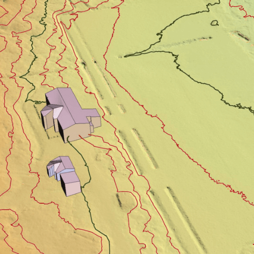
TerraScan is the main application in the Terrasolid Software family for managing and processing all types of point clouds. It offers import and project structuring tools for handling the massive number of points of a laser scanning campaign as well as the corresponding trajectory information. Various classification routines enable the automatic filtering of the point cloud. It is particularly effective for LiDAR data.
TerraModeler
Create, edit, and utilise surface models. TerraModeler creates surface models (TINs) from various sources, such as LiDAR points stored in binary files or loaded in TerraScan, XYZ ascii files and graphical design elements. The software offers versatile visualisation options including coloured shaded surfaces, contour lines, grids, coloured triangle nets, elevation texts, slope directions and textured surfaces (in combination with TerraPhoto).
TerraMatch
TerraMatch is a sophisticated tool for improving the accuracy and quality of the raw laser point cloud. It compares laser data from overlapping flight or drive paths and calculates correction values for the misalignment angles as well as xyz location errors.
TerraPhoto
TerraPhoto is specifically developed for processing images captured together with laser data during a survey mission. The software enables the production of rectified images and ortho mosaics based on the ground model that has been extracted from the laser data. The positioning of the source images can be refined by using tie points for image-to-image adjustment while ground control points can be involved for improving the absolute accuracy of the image block. TerraPhoto lets you create ortho photos of good positional and colour-coordinated quality.


